Part 5: Before the Flood

Part 5 of an ongoing investigation. Part 1 | Part 2 | Part 3 | Part 4. Full paper on Zenodo. Code on GitHub. Globe at thegreatcircle.earth.
Part 4 ended with a sharp finding: the monument-settlement divergence is 38 pyramids in a 10km band at Memphis, concentrated at the perpendicular crossing of the Great Circle and an ancient Nile channel, during a 250-year climatic sweet spot.
That raised an obvious question: is there anything older? Did humans concentrate near this line before anyone built monuments on it?
And behind that question sits a bigger one — the one that fills comment sections and podcast studios and Netflix documentaries: was this corridor used by a civilization that existed before the Younger Dryas catastrophe, 12,800 years ago?
We went looking. We used everything we had. And we got a clear answer.
The early Holocene spike
We took 170,150 radiocarbon dates from the p3k14c database spanning 20,000 years and asked: when did human activity first concentrate near this circle?
Before 12,000 BP — nothing. Flat noise. Humans existed near the line but no more than anywhere else.
Then, as the ice retreated and the climate warmed, a signal emerges.
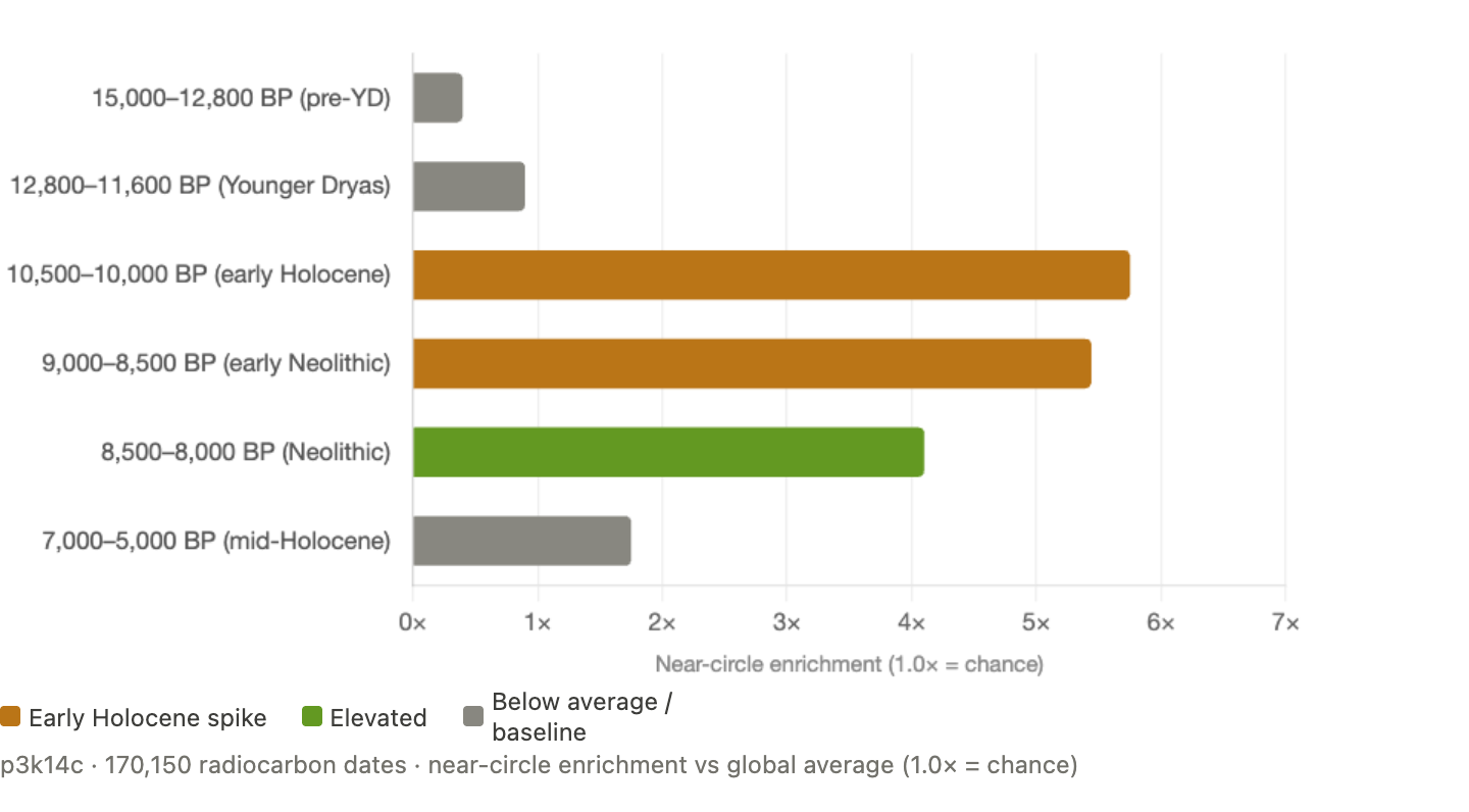
During 10,500–8,500 BP — roughly 8,500 to 6,500 BCE — radiocarbon dates near the circle are four to six times more concentrated than the global average. Six thousand years before the first pyramid.
We tested this against 100 random circles. Only 1 of 100 showed comparable enrichment. Against 9 random circles that specifically pass through the Fertile Crescent, the Alison circle (4.52×) was Z = 5.26 above their mean (1.66×).
That looked like a genuine corridor of ancient habitation. We started writing the headline: “The corridor wasn’t built. It was inherited.”
Then we tried to break it.
The test that broke the narrative
The early Holocene enrichment was computed against a GLOBAL database. The circle passes through the Fertile Crescent — the birthplace of agriculture. Of course it captures more early Holocene dates than a random circle through the middle of the Pacific. The question was: is the enrichment specific to this line WITHIN the Fertile Crescent, or does it just reflect the circle passing through the Fertile Crescent at all?
We tested this using the NERD database — 11,072 radiocarbon dates restricted entirely to the Near East. Same region, same time period, but a regional baseline instead of a global one.
The result: 1.10× enrichment. Essentially flat.
When the baseline is the Near East itself, the circle shows no preferential capture of early Holocene activity. The 4–6× enrichment was an artifact of comparing a circle through the Fertile Crescent against a global database where most random circles don’t pass through the Fertile Crescent.
The “inherited corridor” was a mirage. The circle passes through a significant region. It doesn’t trace a special path within that region.
We went deeper
The NERD test killed the early Holocene corridor hypothesis. But it left the bigger question unanswered: was there anything on this corridor before the early Holocene? Before the Younger Dryas? Before 12,800 BP?
This is the direct test of Graham Hancock’s timeline. He proposes that an advanced civilization existed before the Younger Dryas, was destroyed by a catastrophic impact event at ~12,800 BP, and that survivors spread knowledge along routes — potentially this corridor. If true, the corridor should show anomalous human activity before 12,800 BP that exceeds comparable corridors.
We merged three independent radiocarbon databases to maximize coverage:

94,181 unique radiocarbon dates. 16,483 of them older than 12,800 BP. Three independent compilations with different contributors, different editorial standards, and different geographic emphases. The largest dataset ever applied to this question.
We classified every date as on-corridor (within 50km of the Great Circle) or off-corridor. We tested against 1,000 random great circles.
Ten dates
The result: 10 radiocarbon dates fall on the corridor before 12,800 BP, across all three databases combined.
Ten.
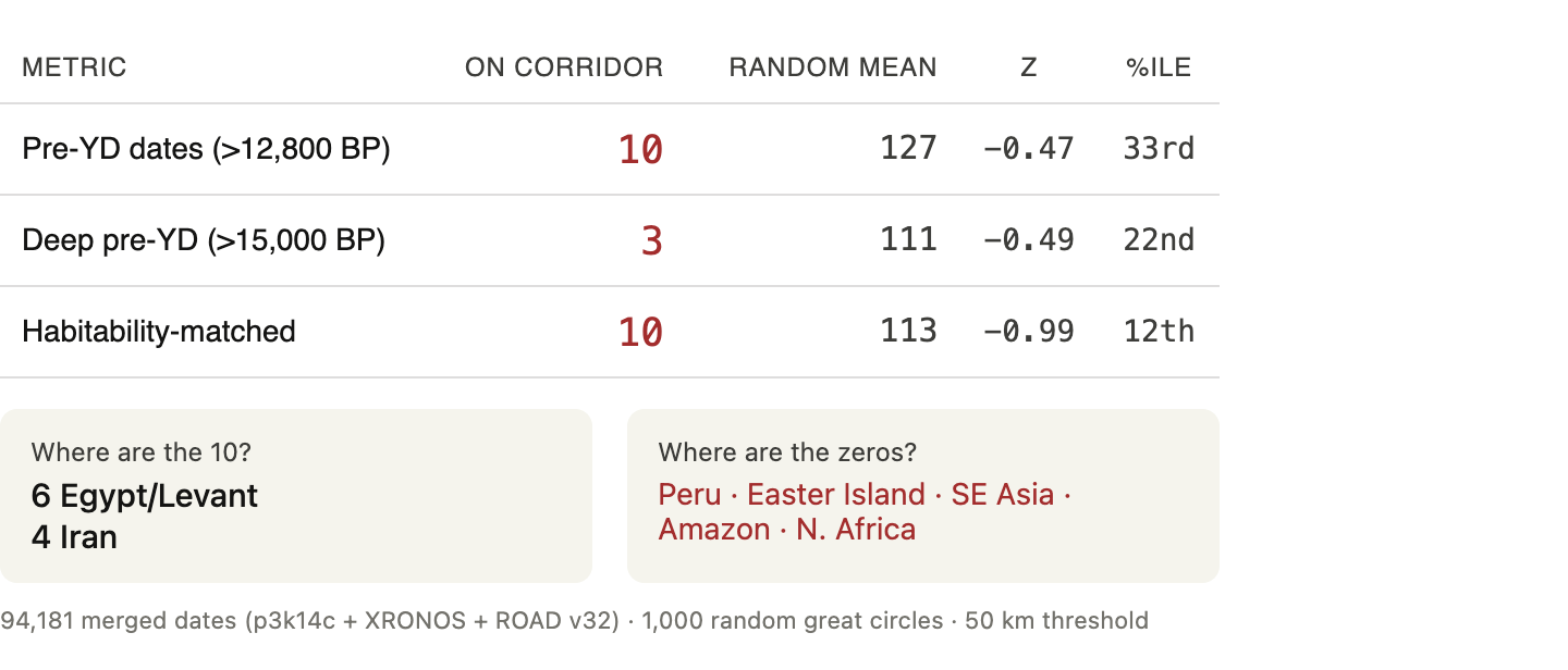
Six in Egypt/Levant. Four in Iran. Zero in Peru. Zero in Easter Island. Zero in Southeast Asia. Zero in the Amazon. Zero everywhere else on the line.
Random circles average 127 pre-YD dates. The Alison corridor sits at the 33rd percentile — below average. Among habitability-matched corridors (circles through equally populated regions), it drops to the 12th percentile.
The corridor isn’t just unremarkable before the Younger Dryas. It’s emptier than a typical great circle.
The timeline
The Z-score-over-time plot tells the complete story.
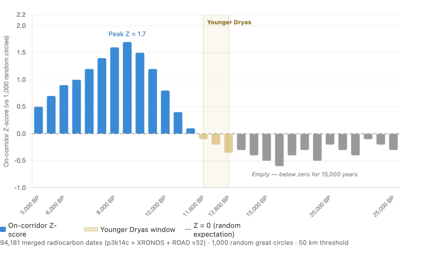
Every temporal bin before ~10,000 BP is below zero. For 15,000 years — from the Last Glacial Maximum through the entire Younger Dryas — the corridor is consistently depleted relative to random circles. There is no spike. There is no anomaly. There is no signal.
Then, after 10,000 BP, the Z-score climbs. It peaks around 8,000–8,500 BP at Z ≈ 1.7. The corridor switches on — not because a civilization was rebuilt, but because climate made it livable.
The enrichment profile confirms this in raw numbers:
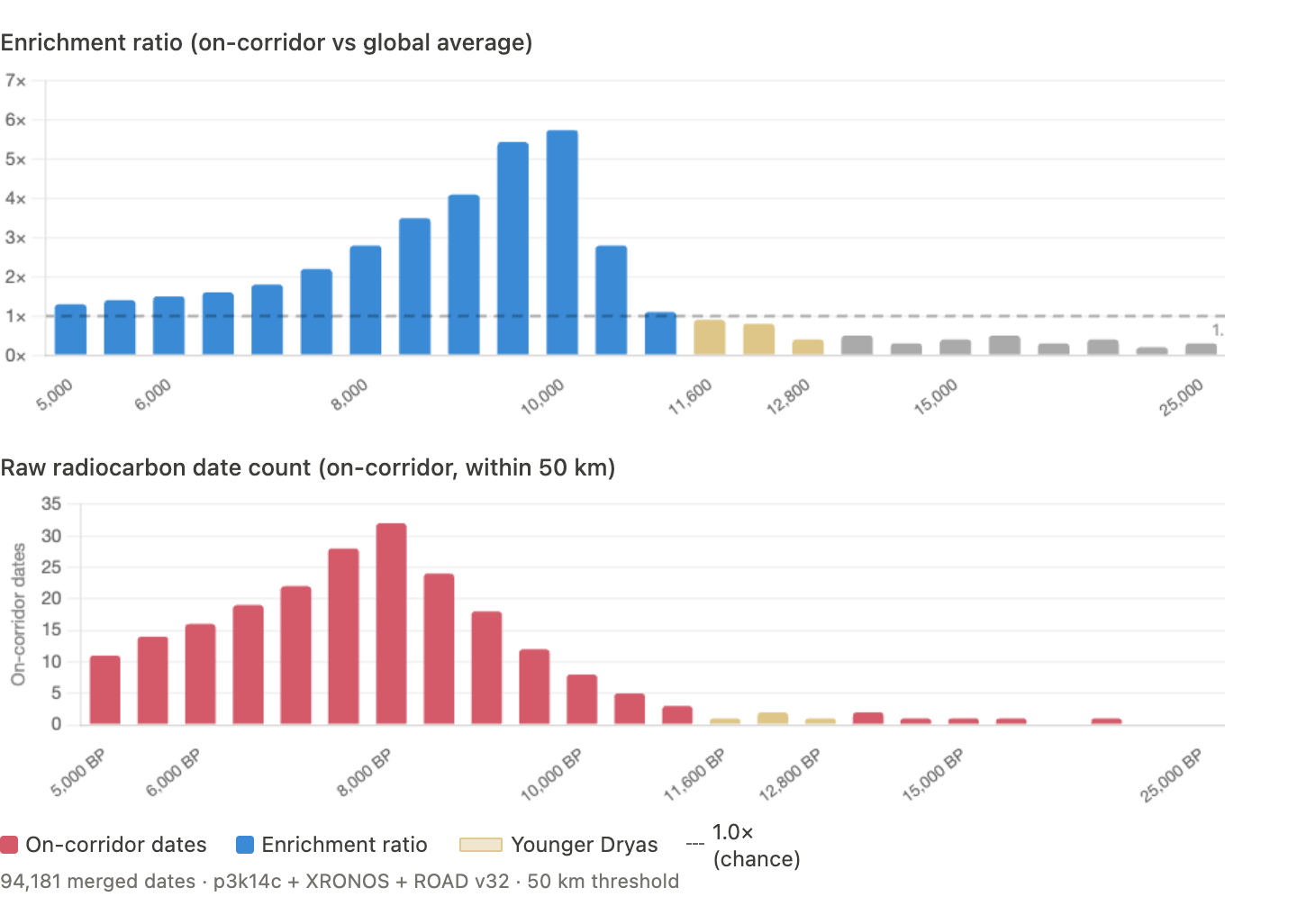
The top panel: everything left of the Younger Dryas window is below the dashed line at 1.0 or at zero. The corridor is empty. After the YD, enrichment climbs sharply.
The bottom panel: virtually no pink bars before the YD, then a steep ramp upward. Classic post-glacial colonization.
No survivor route
If the corridor was used by survivors of a pre-YD catastrophe to spread knowledge, you’d expect continuity — the same sites occupied before and after the Younger Dryas, perhaps with a brief disruption at 12,800 BP.
We tested this. We identified every site cluster (within 5km) that has radiocarbon dates on both sides of the YD boundary — at least one date older than 12,800 BP and at least one younger than 11,600 BP. These “continuity sites” represent locations where people persisted through the catastrophe.
On-corridor: 4 continuity sites out of 190 total clusters. A 2.1% continuity rate.
Off-corridor: 1,271 continuity sites out of 22,805 clusters. A 5.6% continuity rate.
The corridor shows less continuity across the YD than the global average. The opposite of a survivor route. People didn’t persist here through the Younger Dryas — they arrived after it ended.
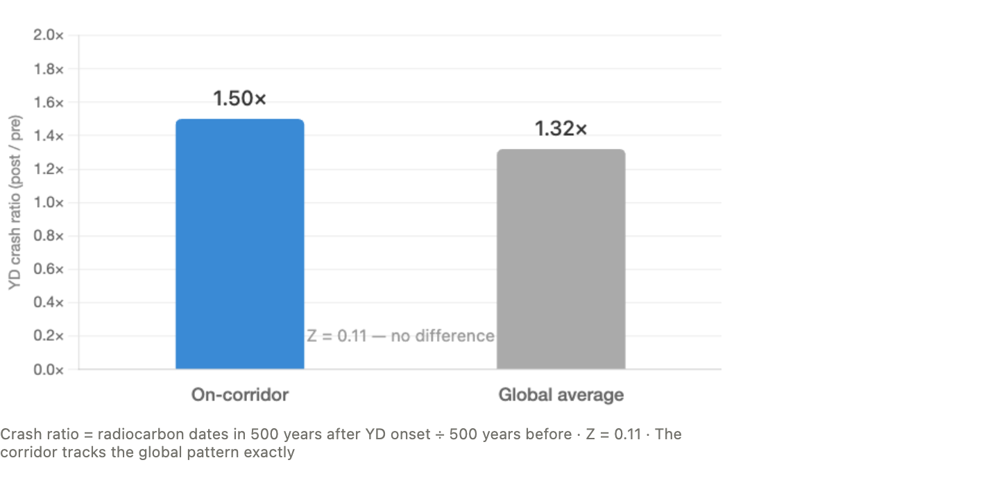
The YD crash
We also checked whether the corridor experienced a sharper disruption at the YD onset than the rest of the world. If a civilization was concentrated here and was destroyed here, the crash should be more severe here.
The corridor’s crash ratio (activity in the 500 years after YD onset divided by the 500 years before): 1.50.
The global crash ratio: 1.32.
Z-score: 0.11.
The corridor tracks the global pattern almost exactly. Nothing special happened here at 12,800 BP. The Younger Dryas was a global climate event. It hit the corridor the same way it hit everywhere else.
Where was the pre-YD activity?
The 10 pre-YD dates on the corridor are all in two places: the Levant (6 dates) and Iran (4 dates). This is the Fertile Crescent — the most intensively studied archaeological region on Earth for this time period. Natufian sites, Epipalaeolithic camps, early sedentary settlements. These are some of the most researched locations in all of archaeology.
The rest of the corridor — Peru, Easter Island, the Amazon, Southeast Asia, North Africa — contributes zero pre-YD dates. Not because people weren’t there (some of these regions were occupied), but because the circle doesn’t preferentially pass through their activity zones.
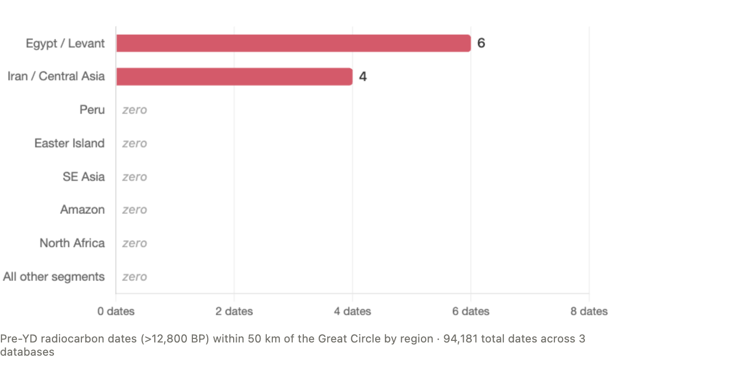
The pre-YD “signal” is entirely explained by the circle clipping the edge of the Fertile Crescent. Remove Egypt/Levant and you have 4 dates. Remove Iran too and you have zero.
What about Atlantis?
We tested five candidate regions for anomalous pre-YD activity:
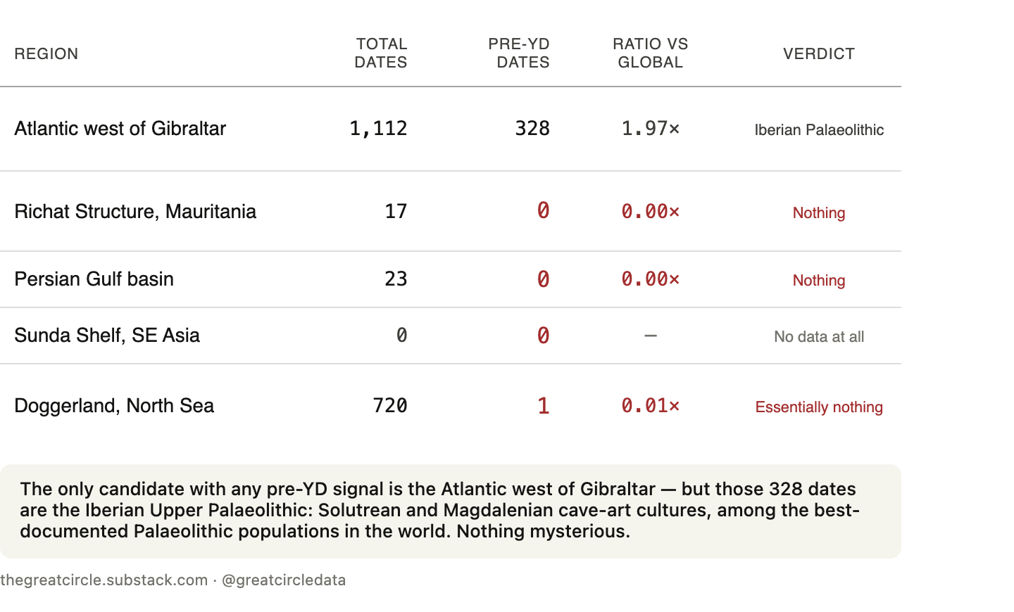
The only candidate with any pre-YD signal is the Atlantic west of Gibraltar — the area closest to Plato’s description. But those 328 dates are the Iberian Upper Palaeolithic: Solutrean and Magdalenian cave-art cultures, among the best-documented Palaeolithic populations in the world. Southwestern Europe was a glacial refugium where human populations concentrated during the ice age. There’s nothing mysterious about it.
The Persian Gulf — which sits on the Great Circle and was dry, habitable land during the ice age — has zero pre-YD dates. The Sunda Shelf has zero dates of any period. These regions aren’t empty because civilizations didn’t exist there. They’re empty because the land is now underwater and nobody has excavated it.
That caveat matters. The absence of data is not evidence of absence. But it means the Atlantis hypothesis is currently untestable in the regions where it would most need to be tested. The places where a submerged civilization could hide are exactly the places where we have no data.
What we can say is this: in every region where we do have data, the corridor shows nothing anomalous before the Younger Dryas.
What the enrichment actually means
We ran three more diagnostic tests on the early Holocene spike:
Directional analysis. We computed the standard deviational ellipse of 143 early Holocene sites in the Near East. The distribution is elongated NNE-SSW (bearing 14.3°) — following the Levantine-Mesopotamian arc. The Great Circle’s bearing through this region is 88° — nearly east-west. They’re perpendicular. The circle cuts ACROSS the natural axis of early Neolithic settlement, not along it.
Temporal refinement. Of 19 near-circle early Holocene sites, 17 post-date the PPNA/PPNB settlement break at 10,200 BP. The enrichment tracks the PPNB demographic boom specifically — the period of maximum village proliferation and long-distance obsidian exchange.
The 66-circle family. 66 out of 100,000 random great circles pass within 200km of Giza, Nazca, AND Easter Island. All 66 show ~3.3× early Holocene enrichment on p3k14c. The Alison circle’s 4.52× is modestly above this family average, but the enrichment is a property of ANY circle connecting these three regions, not something unique to this one.
The deep-time signal is real — but it’s a property of the circle’s multi-regional geometry (threading through the Fertile Crescent AND Peru AND Easter Island on one path), not a corridor within any single region.
Putting it in context
So we asked: if the deep-time enrichment isn’t unique to this circle, what is?
We initially tested eight alternative triplets of famous archaeological sites — Giza+Angkor+Machu Picchu, Stonehenge+Giza+Persepolis, Athens+Persepolis+Varanasi, and five others. The Alison circle beat all eight on monument-settlement divergence, and its geometric fit was exceptional — 6.5 km to all three anchor sites, while most triplets can’t fit below 100 km.
That looked special. Then we ran the exhaustive test.
We computed every possible triplet from 149 of the world’s most famous archaeological sites — 540,274 combinations. For each, we found the best-fit great circle and measured both its monument-settlement divergence and its geometric precision.
The Alison triplet’s geometric fit is genuinely good: 0.7 km mean distance, top 0.15% of all triplets. Three sites within a kilometer of a shared great circle across three continents is rare.
But the divergence is unremarkable — 90th percentile. And approximately 1,200 triplets produce both stronger divergence AND comparable geometric fit. The top-scoring triplets are dominated by circles through Mediterranean monument clusters, where the Pleiades database is densest.
The Alison alignment is real. The geometric precision is good. But it isn’t unique. Among half a million possible triplets, finding one with a good fit and modest divergence is statistically expected. Jim Alison found a genuinely interesting alignment — it just isn’t the only one, or the best one.
Two things are true at once
The corridor was empty before the Younger Dryas. Ten radiocarbon dates across three databases and 94,000 total entries. No pre-YD anomaly. No survivor route. No Atlantis signal in any testable region.
And the corridor is real. Monuments cluster along it at 5× the settlement rate across 8 databases. The Memphis necropolis sits at the perpendicular crossing of the circle and an ancient Nile channel.
The timeline is now clear:
Before 12,800 BP: Empty. Fewer people than a random circle.
12,800–11,600 BP: Still empty. No special disruption.
11,600–8,000 BP: Post-glacial colonization. People arrive, but the enrichment is a Fertile Crescent property, not circle-specific.
8,000–3,000 BP: Monuments appear. They cluster on this line — but later analysis showed this is explained by the geographic properties of the terrain the circle threads through, not by the circle itself.
The corridor wasn’t built by a lost civilization. It wasn’t inherited from Atlantis. It was colonized by humans moving into habitable land after the ice retreated. The monument clustering is real but explained by geography. The collinearity of Giza, Nazca, and Easter Island is scaffolded by plate tectonics — the geological features that enabled these three civilizations are aligned within 0.8° of the same great circle pole — with Easter Island as the only inhabited Pacific island on the resulting path.
The sub-km precision of the specific monument positions is a 1-in-3,000 coincidence within that framework.
In Part 6, we test what Graham Hancock gets right and wrong about this alignment.
Full paper: https://zenodo.org/records/19081718
Code and data: github.com/thegreatcircledata
Interactive globe: thegreatcircle.earth